


snowhow freeride
توضیحات snowhow freeride
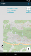
The SNOWHOW-Freeride App offers offline use of maps from the Alps. With an adjustable layer you can check the incline (steepness) of the slopes.
The slope incline is a key parameter for European decision making strategies in wintery and avalanche prone terrain.
The SNOWHOW-Freeride App is no substitute for any other tools of orientation and decision making and necessary safety gear. Shown tracks and map information are not recommendations for any terrain use.
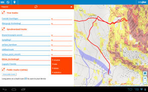
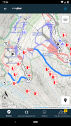
Track recording:
The GPS-function of your phone allows you to find your current position on the map.
Combined with the color coding of the slope incline, you can evaluate the terrain around you.
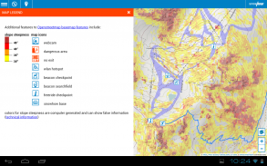
Color coding for incline:
The color coding shows the steepness of the terrain in four sectors.
These sectors are used in decision making strategies in Europe. The knowledge and correct use of decision making strategies (see http://goo.gl/y5Rmx ) is essential to be able to use the SNOWHOW-Freeride App properly. If you are not familiar with any kind of decision making strategies or any other knowledge about decision making in avanlanche prone terrain, do not use the SNOWHOW-Freeride App.
Resolution and color coding:
Each color coded tile shows an area of 10 x 10 metres or real terrain. Keep in mind, that within 10 metres the steepness of a slope can change dramatically.
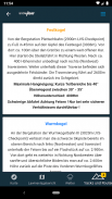
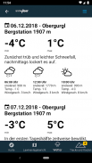
Weather data and Avalanche Bulletin:
If you go online with your smartphone, the SNOWHOW-Freeride App will automatically load the newest avalanche bulletin.
برنامه SNOWHOW-Freeride استفاده آفلاین از نقشه های آلپ را ارائه می دهد. با یک لایه قابل تنظیم می توانید شیب (استحکام) دامنه ها را بررسی کنید.
شیب شیب یک پارامتر اصلی برای استراتژی های تصمیم گیری اروپا در زمین های مستعد زمستانی و بهمن است.
برنامه SNOWHOW-Freeride جایگزینی برای ابزارهای دیگر جهت گیری و تصمیم گیری و تجهیزات ایمنی لازم نیست. آهنگ های نمایش داده شده و اطلاعات نقشه توصیه ای برای استفاده از زمین نیست.
ضبط آهنگ:
عملکرد GPS تلفن شما به شما امکان می دهد موقعیت فعلی خود را روی نقشه پیدا کنید.
همراه با کدگذاری رنگ شیب شیب ، می توانید زمین اطراف خود را ارزیابی کنید.
کدگذاری رنگ برای شیب:
کدگذاری رنگ ، شیب تندی زمین را در چهار بخش نشان می دهد.
این بخش ها در استراتژی های تصمیم گیری در اروپا استفاده می شوند. دانش و استفاده صحیح از استراتژی های تصمیم گیری (مراجعه به http://goo.gl/y5Rmx) ضروری است تا بتوانید به درستی از برنامه SNOWHOW-Freeride استفاده کنید. اگر با هر نوع استراتژی تصمیم گیری یا هر نوع دانش دیگری در مورد تصمیم گیری در زمینهای مستعد بهمن آشنا نیستید ، از برنامه SNOWHOW-Freeride استفاده نکنید.
وضوح و رمزگذاری رنگ:
هر کاشی دارای کد رنگی مساحت 10 10 10 متر یا زمین واقعی را نشان می دهد. به خاطر داشته باشید که در طی 10 متر شیب شیب می تواند به طرز چشمگیری تغییر کند.
اطلاعات آب و هوا و بولتن بولتن:
اگر با تلفن هوشمند خود به صورت آنلاین بروید ، برنامه SNOWHOW-Freeride به طور خودکار جدیدترین بولتن بهمن را بارگذاری می کند.
snowhow freeride - نسخه 2.0.26
(02-11-2021)snowhow freeride - اطلاعات APK
نسخه APK: 2.0.26حزمة: info.snowhowآخرین نسخه snowhow freeride
سایر نسخهها


 4.63
4.63اپلیکیشنها در دسته مشابه

شاید دوست داشته باشید...


